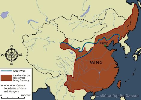
This is the map of the Ming Dynasty.(1368-1644 CE) The shaded region in brown was the Ming territory. The Black dotted lines show the current boarder of China with Mongolia. The thick blue line crossing The Ming Dynasty territory is symbolizing the Great Wall Of China's location. The map shows the location of China's current capitol, Beijing. Zhu Yuangzhang, also known as emperor Hongwu was the first ruler of the Ming Dynasty, he was also one of the first rulers to rise from poverty. Within four years emperor Hongwu had full control of the territory once held by the Tang Dynasty. He was also the first emperor to rule a United China. Yangtze River crossed through the Ming Dynasty, it is the longest river in Asia. The location of the Ming Dynasty was very convenient because it was on the boarder of East China Sea. The Ming Dynasty controlled a lot of land and important land marks, the Ming Dynasty ruled for many years, years that were remembered.
No comments:
Post a Comment